
Presentación
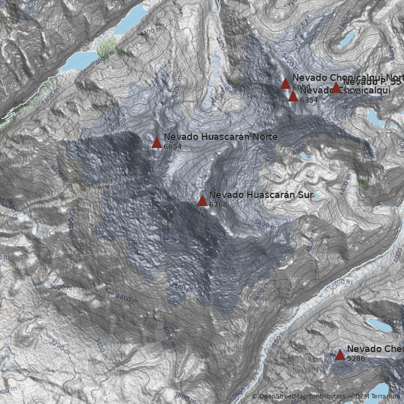
Las cumbres gemelas del Huascarán constituyen las más prominentes y altas del Perú, dominando la totalidad del valle del río Santa. El Huascarán es también la montaña tropical más alta de América, hecho que ha atraído numerosas expediciones de todas partes del mundo desde comienzos del siglo XX.
Respecto al origen del nombre hay diversas versiones: en el mapa de Ancash del explorador Antonio Raimondi (1873), el nevado aparece con el nombre de Huascán, que significaría "atractivo" o "tentador" según el estudioso G. Stiglich (1922). Esta misma persona, plantea que habría existido una propiedad cercana a la montaña llamada Hacienda Huascarán, aunque no menciona si la hacienda fue llamada después del nevado o viceversa. Otros, atribuyen el origen del nombre al Inca Huascar.
Origen de la Cordillera Blanca
Una triste leyenda cuenta el origen de la Cordillera Blanca: “La más alta montaña, Huascarán, fue una vez una mujer que tuvo numerosos hijos. El marido de Huascarán, Canchón, fue seducido por Sutoc quien era una mejor cocinera. Celosa, Huascarán castró a su marido y luego huyó seguida por sus hijos, el mayor la acompañaba de cerca, mientras que el menor iba bastante lejos. El hijo favorito fue cargado por Huascarán en su espalda. Cuando fueron a descansar, toda la familia se transformó en la Cordillera Blanca, y sus lágrimas causaron los arroyos que dieron forma a los ríos Santa y Marañón.
Canchón se volvió piedra y llegó a ser la más bella montaña de la Cordillera Negra. Su amante Sutoc y sus hijos también se transformaron en otras montañas de la Cordillera Negra y sus lágrimas crearon los cauces y arroyos de esa región.” *
Desastre de Yungay
Durante los últimos siglos se han producido varios desastres asociados a eventos glaciales en el Nevado Huascarán. La peor de todas estas catástrofes ocurrió el 31 de mayo de 1970, cuando los movimientos inducidos por un fuerte terremoto causaron desprendimientos de glaciares en el Huascarán Norte, produciendo el aluvión más horrible hasta entonces registrado. El aluvión no sólo bajó por el río Shacsha, sino que parte de él incluso logró superar una colina y, posteriormente, enterrar completamente el pueblo de Yungay, incluyendo aproximadamente 17.000 personas. Irónicamente, lo único que se salvó de la devastación fue el cementerio de Yungay.
Actualmente, todo este sector está declarado campo santo.
Principales Rutas
- Glaciar Oeste-Rampa Norte (AD sup. “ruta de la Garganta”): H. Bernard (AT), P. Borchers (DE), E. Hein (AT), H. Hoerlin (DE) y E. Schneider (AT), 20 de Julio de 1932. Aproximación desde Yungay hasta el glaciar Oeste. Ascensión por “la garganta” y cara NW de cumbre sur. Primera ascensión absoluta al Huascarán Sur por parte de una expedición del Club Alpino Austro-Alemán por la que hoy es considerada la ruta normal.
- Glaciar Suroeste-Arista Sureste (D sup.): F. Ayres, H. Kendall, W. Mathews, D. Michael, J. Ortenburger y L. Ortenburger en 1958.
- Arista Noreste (MD sup., ruta Española): A. Acuña (ES), F. Mautino (ES), A. Pérez (ES), S. Rivas (ES), J. Pons (ES) y J. M. Anglada (ES) en 1961.
- Arista Oeste (D sup., ruta del Escudo): W. Broda, J. Merler y B. Segger en 1969.
- Cara Este (MD sup., ruta Anzus): P. Coradine, R. Ryan, R. Schneider y G. Wyatt en 1971
- Arista Sureste (MD): B. Jenkinson, M. Jones y J. Strang en 1971.
- Cara Este (ED inf., ruta Austriaca): S. Hasitschta, E. Koblmuller, E. Lacker, C. Pollet y R. Schulz en 1972
- Canaleta Este (MD sup.): J. Selga, J. Vinyoli y J. M. Monfort en 1978.
- Cara Este (ED, ruta Austriaca directa): F. Six (AT) y A. Indrich (AT) en 1979.
- Cara Este (MD sup., variante de 1980): R. Blatherwick en solitario en 1980.
- Cascada de Hielo Este (D): J. Agulló, J. Anglés, T. Bros, J. Prunés, R. Biosco y R. Pajares en 1980.
- Cara Noreste (MD, ruta Francesa): B. Grison (FR) en solitario en 1985.
- Cara Noreste (MD, ruta Eslovena): P. Kozjek (YU) en solitario en 1991.
- Pilar Noreste (ED, ruta Eslovena, Carretera al infierno): M. Kovac, B. Lozar y T. Petac en 1993.
Notas
*Leyenda extraída del libro: Yuraq Janka, Guide to the Peruvian Andes. Autor: John F. Ricker, pág. 1.
Más información sobre otras ascensiones al Huascarán Norte y Sur en el mismo libro.
**La altura de 6.746 m. y 6.655 m. asignadas al Nevado Huascarán Sur y Norte respectivamente, están extraídas de la Hoja Carhuas del Instituto Geográfico Militar de Lima, Perú.
***La altura de 6.768 m. otorgada al Huascarán Sur y 6.654 m. al Huascarán Norte, están asignadas por la D.O.S. (Deutscher Alpenverein) en su carta “Nevado Huascarán, Cordillera Blanca, Perú”, publicada en Viena, 1964 (?).
Referencias
- South America, Peru, Andes. American Alpine Journal, 1933.
- Borchers, Philip (1933). In the Cordillera Blanca; the 1932 D.&Oe.A.V. Expedition. American Alpine Journal.


