

Summary
General Information
Cerro Gabriela Mistral (3547 m.)
Southeast Ridge
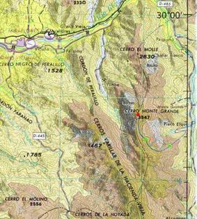
Country: Chile
Region: Región de Coquimbo
Area:
Face: Sureste
Altitude gain: 2000 m. desde Measured from Pisco Elqui (aproximately)
Number of journeys: 0
Trail: Claro y marcado
Difficulty (3)

I did it
Mountain route
SOUTHEAST RIDGE
Appropriate season
Monte Grande can be climbed all year around, but it is specially beautifull in winter when the higher parts are covered in snow. The hard snow of winter also makes it easier to walk.
Access
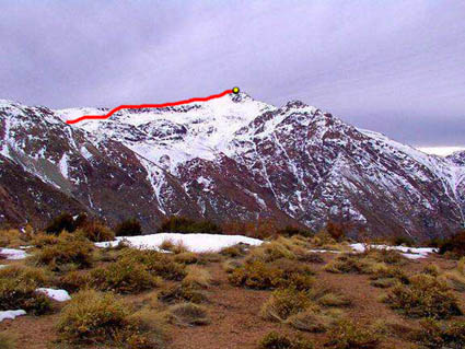
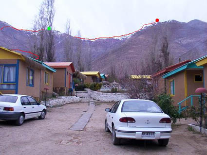
The moutain is accessed from the town Pisco Elqui. It is about 120Km from the coastal town of La Serena, passing by Vicuña. There is no need for permits from local authorities. The climb starts from Pisco Elqui (See photo 1).
Approach
The aproximation is straightforward from Pisco Elqui.
The climb
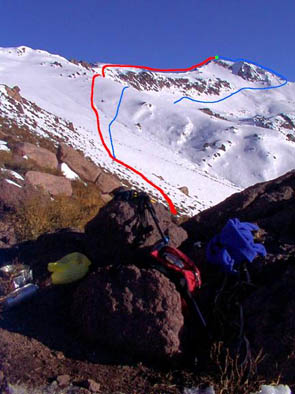
To get to the begining of the route, from the Plaza de Armas at the heart of Pisco Elqui, as if you were going to Alcoguas (a village south from Pisco - See photo 6), turn left and then take the first little road to the right (going south-west direction). At the end of this road begins a dirt road that runs along the lowest parts of the ridge (that will be in your left hand!) where the route begins. Go up this road until you see an obvious erosion depression on the hill side to your left. Start going up the ridge at this point aproximately. There is kind of a trail that can be followed, not very obvious and hard to find in the begining, but basically just take the ridge line.
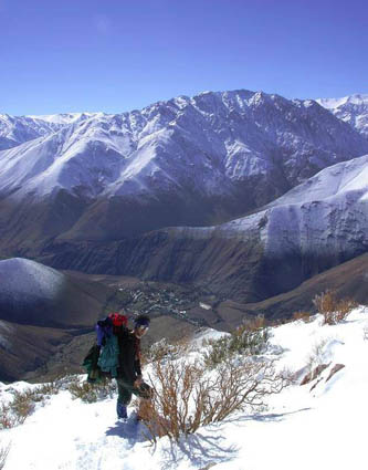
It takes about 5 to 6 hours with packs to reach the little man made shelter (See photo 4) at ~3100m. It is about 3 hours more to the summit depending on conditions. The route has an inclination of about 30-40 degrees at the steepest parts.
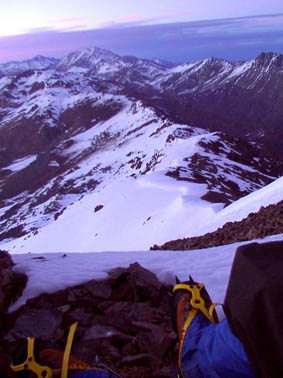
The ascent can be done in as many stages as one wishes. The standard is two days, one going up and camping close to the summit (or doing the summit) and one going down. It is nice to camp before reaching the summit and to climb up to the summit just before sun rise, which is a beautifull show!
The route is really easy with no rock climbing required. During winter use of crampons and an ice axe is recomended, specially along the ridge route.
Gear
Schedule
Schedule 1
- La Serena - Pisco Elqui - High Camp
- High Camp - Summit- La Serena
Schedule 2
- Pisco - Summit - Summit
If visiting the village of Pisco Elqui, the mountain can be climbed in a day.

ROUTE STATUS
Southeast Ridge | Cerro Gabriela Mistral.
El propósito de los reportes de estado de ruta es entregar información reciente acerca de las condiciones de una ruta en particular. No es condición para hacer un reporte de ruta que hayas llegado a la cumbre. Muchas veces la ascensión completa de la ruta se debe a la existencia de un impedimento de realización reciente sobre el cual es muy importante compartir información para quienes están preparando una visita al cerro o ruta ¿Has intentado esta ruta recientemente? Entonces entrega tu reporte del estado de la ruta aquí. Para hacerlo debes logearte o registrarte.
Felipe Prado14/06/2020
Punto alcanzado: Cumbre
Fecha expedición: 30/09/2017
es la ruta desde pisco elqui, la mas conocida. en la parte baja es dura y en la mitad del cerro comienza levemente a normalizares
Tracks and Waypoints
Southeast Ridge | Cerro Gabriela Mistral.
No hay tracks ni waypoints disponibles.
I did it!